What makes the Cut? Choosing maps for Know Your Place
Peter Insole reveals the selection criteria for maps added onto Know Your Place.
Know Your Place (KYP) was created in 2011 with funding from English Heritage (now Historic England) with the intention of sharing as much information about the history of Bristol as possible. One of the main historic sources we wanted to make available were the fantastic range of historic maps that are held in the Bristol archives. However, not every map is suitable for publishing on an online resource like Know Your Place. In the first place we need digital copies of the maps, secondly the maps need to be accurately surveyed plans and finally they need to be at an appropriate scale.
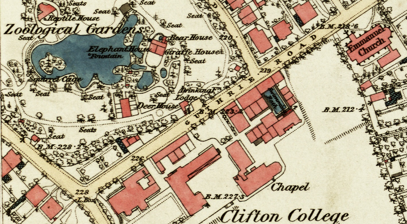
Detail of the 1880s Ordinance Survey map depicting Bristol Zoo.
The first series of maps we prioritised were the mid-19th century tithe maps. These maps were not previously available digitally so part of the funding paid for the specialist scanning of these very large surveys as has been undertaken for the present Know Your Place West of England project. Tithe maps can be matched to the modern Ordnance Survey (OS) mapping with a bit of work and have details that display well at any scale on KYP, although some of the surveyor’s quirks are revealed when you do this. None more so than the Brislington tithe map that is one of the more accurate tithe surveys, although, the surveyor orientated the map with south at the top which means that all the text now appears upside down on KYP.
Other maps do not work so well for KYP. For example the earliest representation of the city, Ricart’s map of 1479 is not an accurate map, although it is possible to recognise features in Ricart’s view that survive in the modern city like the churches of St Nicholas and St Johns as well as the central crossroads of Corn Street, Broad Street, Wine Street and High Street. Clearly it would not be possible to directly overlay Ricart’s view on a modern map in the way historic maps are viewed on KYP. It is not a true survey and it is a bird’s eye view rather than a plan view. The same can be said of other early maps; Smith’s, Speed’s and Hoefnagle’s maps of the 16th century and Millerd’s maps of the later 17th and early 18th century all of which depict a recognisable Bristol, but with similar limitations for direct overlay comparison.
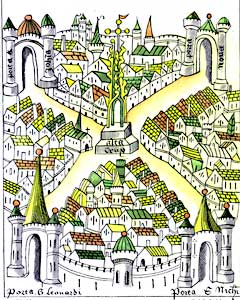
Ricart’s view of Bristol, 1479. BRO 33040/13
The earliest maps that we can use on KYP are the plans created by surveyors like Jean Rocque (1750) and Jacob de Wilstar’s plan of Clifton (1746). Ideally we’d like to use the earlier Rocque plan of 1742 held at Bristol City Museum and Art Gallery because of the greater detail it depicts, but this has not been digitised yet.
In terms of appropriate survey scale, on KYP you can zoom in to a scale of 1:750 which means you can see details like individual trees, benches (marked as seats), letterboxes (L’Box) and drinking fountains on the 1880s map that was originally created by the OS at a scale of 1:2500 or 25” to the mile.
We try to make as many maps as possible available on the site, but there are many challenges to convert a paper map drawn by hand and make it available in digital form to allow their direct comparison to highly accurate modern surveys. It is a testament to the skill of the early surveyors that we can create a resource like Know Your Place and begin to tell the story of the development of the city.
Read more about Bristol Know Your Place here.
By Peter Insole, City Design Group, Bristol City Council.